

Indonesia Geothermal System distribution is strongly controlled by the geology and tectonic setting of the region. This causes, each geothermal system found in this country is unique and vary from place to place. Currently 331 geothermal occurrences and prospects have been mapped by Geological Agency, Ministry of Energy of Mineral Resources Republic of Indonesia (see Figure 12).
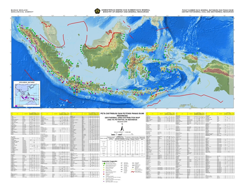
Figure 12 Geothermal Area Distribution Map (KESDM, 2017)
The geology and tectonic setting that form Indonesian Archipelago start as early as Cretaceous age as part of geology and plate tectonic evolution of SE Asia and the SW Pacific (Hall, 2002). The Present day major geology and tectonic framework is shown in Figure 13. It is the result of evolution of subduction zone and its associated magmatic arc since Cretaceous until now, as shown in Figure 14 (Katilli, 1994). It is an extremely complex collection of continental blocks, active and extinct volcanic arcs and associated subduction complexes and old and young ocean basins that form the major tectonic framework of Indonesia. Now, the region is at the convergence of three major tectonic plates: Eurasia, Pacific and Indo-Australia.
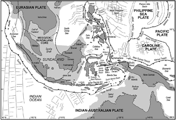
Figure 13 Present day tectonic framework of Indonesian Archipelago (Hall, 2001)
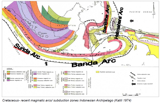
Figure 14 Evolution of Magmatic arc / Subduction Zones of Indonesian Archipelago from Cretaceous-Recent (Katili, 1975)
In general, the present day geology of the archipelago is underlined by two geological basement: continental crust of Eurasian Plate and Australian Plate, and oceanic crust of Pacific Plate Figure 13. The continental crust located at the western region, also known as Sundaland that underlie the three big islands i.e. Sumatera, Java and Kalimantan. Whereas the continental crust at the eastern region, form the basement of New Guinea. The oceanic crust is found in between of both region and covers Sulawesi and smaller islands nearby.
The present day subduction zones, as the result of the movement of three plates, give rise to four active volcanic arc segments. Those are Sunda Arc, Banda Arc, Sangihe Arc and Halmahera Arc. The Sunda and Banda Arc are related to the same subducting Indian Ocean plate (part of Indo-Australian Plate). About 128 active or dormant and many additional extinct volcanoes have been identified along these arcs. The chemical and physical characteristic of the volcanoes at the western and eastern Indonesia are often different that affect the characteristics of volcanic or magmatic associated geothermal system in these areas. Currently, geothermal system associated with volcanism or magmatism are the most exploited resources in this country.
Old subduction zones form tectonic suture that aged from Cretaceous or older. The sutures mostly found in Kalimantan. In Kalimantan, also known as Borneo, uplift, crustal thickening, thrusting and folding occur in many areas. Several major sedimentary basins that produce oil and gas, as well as coal have been found in this island. Several geothermal occurrences, which are indicated by the appearance of warm to hot spring, have been identified. Nevertheless, the association of geothermal heat source with geology of the area has not been well understand. These geothermal occurrences are potential for development of medium to low enthalpy geothermal energy.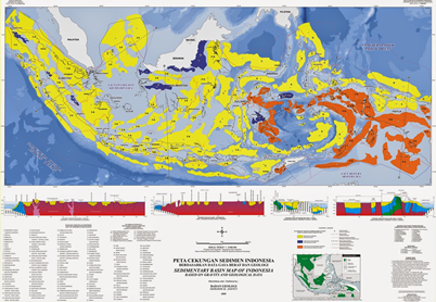
Figure 15 Sedimentary Basin Map of Indonesia (Geological Agency, 2009)
Sedimentary basins can form conduction dominated geothermal system. Total of 128 basins inland and offshore, have been identified by Geological Agency (2009) (Figure 15). Some of them are major oil and gas producers. Geothermal occurrences in the sedimentary basin can be identified as hot water tap from oil well, where many of them are found all over the basins in Indonesia. Although the potential of geothermal energy from sedimentary hot aquifer in Indonesia is significant as shown by many sedimentary basins in the country, but they are poorly understood and lack of investigated.
Geothermal system can be associated with extensional tectonic regime. The occurrence of segmented strike slip faults controls the geometry and permeability of geothermal systems. Several major Young active strike slip faults have been mapped in this country and some of them have been proved to be associated with geothermal system such as Great Sumatran Fault, in Sumatra Island, Palu Koro Fault and its slay to the SE, in Sulawesi, and Cimandiri Fault in West Java. Other possibilities such as Sorong Fault in West Papua and other major fault system has not been investigate yet.
Conduction dominated geothermal type can also occur as in association with old or young orogeny tectonic. Four Orogenic Belt Type have been identified in Indonesia (Simandjuntak and Barber, 1996) shown in Figure 16. They are (1) Sunda Orogeny located at Java Southern Mountain Ranges – Sumatera Barisan Mountain Ranges, (2) Banda Orogeny, located in Sulawesi Mountain Ranges, (3) Melanesia Orogeny in West Papua – Papua New Guinea Mountain Ranges and (4) Talaud Orogeny which is spread at Talaud – Tifore ridge. Nevertheless, the geothermal potential associated with this system has not been investigated yet.
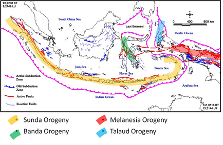
Figure 16 Location of Orogeny Belts in Indonesia with respect to faults distribution and Active and old Subduction Zone
References
- Geological Agency, 2009, Peta Cekungan Sedimen Indonesia http://psg.bgl.esdm.go.id/pameran/index.php?kategori=cekungan-sedimen&halaman=cekungan&title=Cekungan%20Sedimen
- Hall, R., 2002, Cenozoic geological and plate tectonic evolution of SE Asia and the SW Pacific: computer-based reconstructions, model and animations, Journal of Asian Earth Sciences 20 (2002) page 252-431
- Katili, J.A., 1975, Volcanism and plate tectonics in the Indonesian Island arcs, Tectonophysics 26 (3) : 165-188, DOI: 10.1016/0040-1951(75)90088-8
- KESDM, 2017, Potensi Panas Bumi Indonesia, Printed by Direktorat Panas Bumi, Direktorat Jenderal Energi Baru, Terbarukan dan Konservasi Energi (EBTKE-KESDM), 752 pages
- SIMANDJUNTAK, T. O. and BARBER A. J., 1996, Contrasting tectonic styles in the Neogene orogenic belts of Indonesia, in Hall, R. & Blundell, D. (eds), 1996, Tectonic Evolution of Southeast Asia, Geological Society Special Publication No. 106, pp. 185-201
CONTACT
Dr.Eng. ir. Suryantini, MSc (ITB)